A Walk Around Whiston |
|
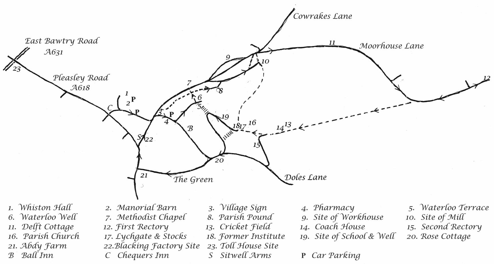
Despite being close to Rotherham, the older parts of Whiston retain their old-world charm; and a stroll round the village can be both interesting and rewarding. The map below shows the route of this walk and covers perhaps the most fascinating features of Whiston. |
|
Click on the map to bring up a full-size version. |
Instructions:
Full instructions are available to download by clicking here. They are also replicated in detail below: Start your walk at the thatched Manorial Barn (2), a Grade 2* listed building. This is one of the oldest structures in South Yorkshire and parts are more than 700 years old – dating back to the reign of King Henry III. An old horse gin on the side facing away from Chaff Lane replaced the use of flails for threshing the corn. Later, this was itself succeeded by a steam engine. The great doors in each half of the barn stand at the end of the two threshing floors (which are still in situ). Inside is an aisled structure; and displays of photographs, farming implements and five fine wall hangings - produced by members of the W.I. - tell of village life and features from past times. |
|
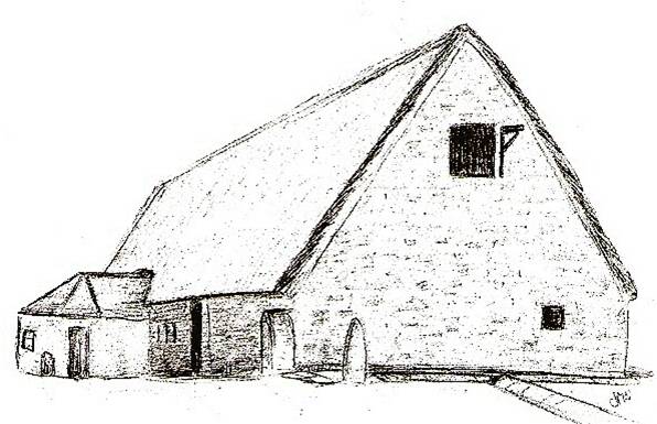
The Manorial Barn |
|
|
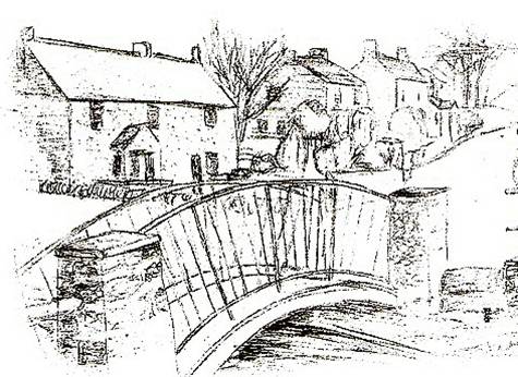
Adjoining the Barn can be seen Whiston Hall (1), a grade 2 listed building. The former farmhouse is now a care home. The early parts of the Hall date from around 1500 although there have been many alterations since then. Between the Hall and the Barn was the Dairy (now a private house) and all of the other farm buildings have now gone. Take a moment to admire the old road sign at the entrance to the Barn, as it once stood at Whiston Cross Roads. Turning left out of the Barn area the Chequers Inn (C) is on the right; one of three Public Houses in the village centre. Turn left down Chaff Lane and cross the High Street by the Village Sign (3) - which shows scenes in the village - into Turner Lane. Many old houses, many dating from C.19 or earlier can be seen. The bridge is over the site of the former ford (below). The Pharmacy, on the right, was formerly Brook House, later to become the Co-op store. Ahead is the Golden Ball Inn (B). |
|
|
|
|
Turner Lane - then and now. |
|
|
Turn left onto Well Lane. The Parish Hall on the left was built in 1963 and is overlooked by Waterloo Terrace (5). Ahead, close to the start of Hollowgate, (and hidden by undergrowth), is the neglected Waterloo Well (or Spout Well) (6) which was once a major source of water for the villagers. Take the path alongside of the Parish Hall. The overgrown site on the right was once the village watercress beds. |
|
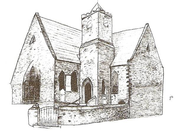
Methodist Church |
|
|
Ahead is the Whiston Methodist Church (7) which was built in 1866 to replace an earlier Chapel constructed in 1822. Prior to this the Methodists met at Stanley Cottage on Hollowgate. In the tower is the Parish Clock, installed in 1874 and paid for by public subscription. A taller wooden spire was struck by lightning in 1949 and thence replaced by the present one. Cross the stream, turn right, and walk alongside the brook. A Heritage Society Plaque marks the site of the Village Pound or Pinfold (8). Turn right along Alma Row, which is named after a battle in the Crimean War. On the left the land rises steeply in an area of the village called Hillside. The Whiston Workhouse (9) was located here. Melrose Cottages (1842) are found at the end of Alma Row as is the site of one of the two Village Water Mills (10). A second plaque can be found here. The dyke water comes from a natural spring on the eastern side of the village at Pinchmill. Climb Mill Hill steps and turn right onto Moorhouse Lane. Change in Whiston started in the 1930s with the building of housing estates on what was once farmland. Old names are preserved simply by the street names. Hunger Hill Lane and Cowrakes Lane are just two examples. Moorhouse Lane provides a glimpse of Whiston's old property style. A good example is Delft Cottage (11) on the left of the road. This family home has been raised by six feet to prevent it being flooded: a problem facing several of the properties that stand alongside the brook (see the 'Themed Research' page for more information on Delft Cottage and the floods of 2007). Moving on, pass the end of Greystones Road and witness more of the recent developments as the road bends round to the left. About 200 yards further along there is a stone house. This was the village's first Rectory (12) and dates from 1720. Note the stone above the doorway with the inscription 'sic vos non vobis' (from a poem by Virgil and translated as 'thus ye toil not for yourselves') and the date. The stone has been retained in the modified building. A cart track ran from the Rectory to the Church - passing through the field entered via a gate that is now on the left hand side 200 yards back. Return to this gate/stile and walk through the field. The land here to the left remains under the plough and so gives an impression of how Whiston would have looked a century ago. Pass the Cricket Ground (13). To your right first of all is Whiston Parish Church Cricket Club, founded in 1904 by Rev. J. Whitehead; and then the Cricket Pavilion completed in 1929 - thanks to the support of Rev. A.G. Alton. Finally you will see the Old Coach House (14) which is now a private residence. This too has been extensively modified and was a staging post in the days of 'coach' travel. Enter the Churchyard where a number of interesting old gravestones can be found; the oldest of which dates back to 1696. |
|
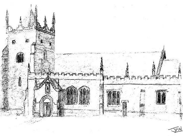
Whiston Parish Church |
|
|
On the left can be seen the Second Rectory (1844) (15), a house of massive Victorian proportions. It was vacated by the Rectors in the 1960s but in its day was used to host parties; where guests would ascend the hill in their carriages in order to attend directly. The gardens were always well kept and the summer fayre/garden party was always held within. The Rectors now live in a more modern building across from it; situated on the former walled garden/orchard of the second rectory. The Church of St Mary Magdalene (16) dates back in part over 800 years and is a Grade 2* listed building. The first Rector was installed in 1236. The tower dates from 1250, however most of the present church dates from Victorian times and is a memorial to Rev. William Howard; Rector for 40 years. In more recent times the interior of the church has been re-ordered to create not just a contemporary church but also two meeting rooms. To the rear (northern side) of the church, the churchyard ends at the edge of the Quarry; a reminder of another important village industry of past times. |
|
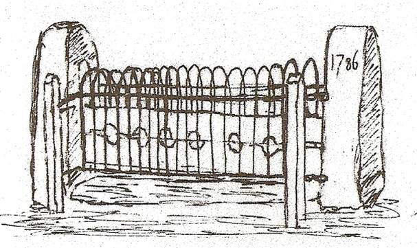
The Stocks |
|
|
On passing through the churchyard, and just before the Lychgate War Memorial (1919) (17); a Grade 2* listed headstone exhibiting a skull and crossbones can be seen. The lychgate lists the names of those who gave their lives in the World Wars, inscribed on two plaques. To the right of the lychgate stands the Village Stocks (1786) (17), these are also listed as Grade 2*. These could seat three people at a time and they were last used c.1870 when Walter "Jabby" Jarvis of Melrose Cottages was put in them. Rumour has it he shouted rude things at passing churchgoers and so was quickly released! Across from the stocks stands Lychgate Hall (18) which is now a private house but was formerly the Church Institute (1913). It was built with money donated by Eliza Rowden Hall - who at the time lived in Sydney, Australia; but originally came from Morthen. On your left stand two cottages: originally the site of the Village Reading Rooms. The first paper, given in 1889 to an audience of men only, was "Our outdoor games, their uses and dangers". The building had initially been constructed as a Boarding School and was set up in 1794. In the 1840s and 1850s it was run by a Mrs Elizabeth Davidson and her son William. About 30 boys - mainly from other parts of the country - used to board there. The school closed in 1860. Down School Hill, and behind Lychgate Hall, is an old Water Tower. This held a tank used for storing water used at the Rectory. The water supply was drawn up from a well that stood in the Old School Yard (19) directly below using 'horse' power. This well is currently being refurbished. The Old School Yard is now filled with houses but was originally the site for the Old Village School (1838). As the village grew, so the school was improved also; firstly in the 1870s and then secondly enlarged in 1894. The facility remained as such until the mid C20: only being replaced in 1961 by a new school (Whiston J&I on Saville Road) built among the new housing estates. |
|
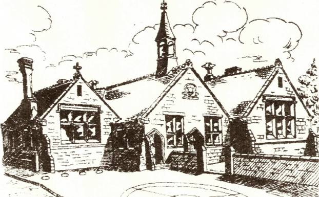 A Drawing of the Old School - now demolished |
|
|
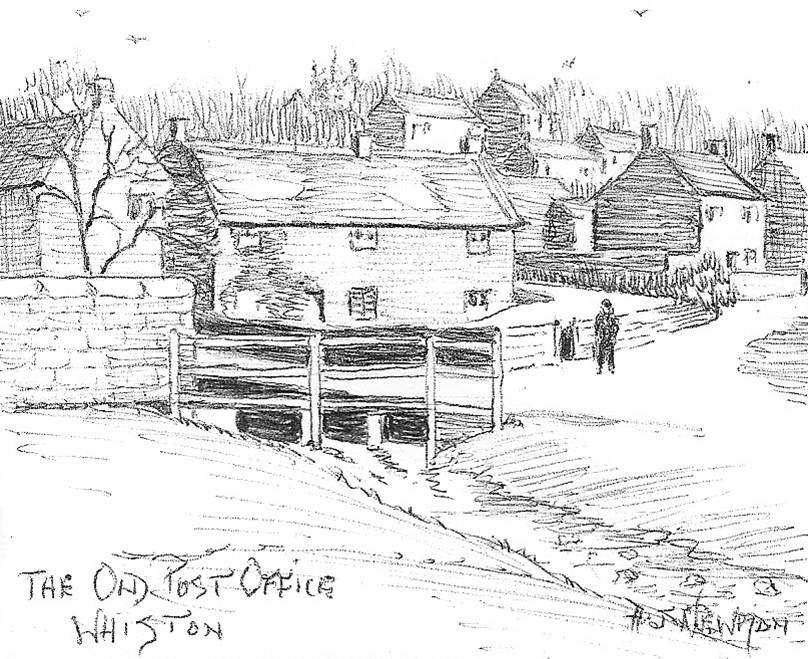
Still existing from the old school are the entrance posts and one small building which was the Old Soup Kitchen (1836). Among other things, this was used to serve meals during the Miners' Strike of 1926. Follow the road round to Doles Lane. Old farm buildings are directly ahead and these are now private homes. What is more, on the right is a selection of bungalows called Sorrel Sykes. These are named after the book by Armitage - a local man. After turning right down The Green, we can see Rose Cottage (20) (c.1700) on the left hand side of the road. This has recently been restored as a private dwelling but had previously functioned as another staging post for coaches and as the Old Village Post Office prior to the Armitage family taking up residence there. Wood View Terrace (1893) stands almost opposite whilst other houses on The Green are a mixture of old cottages and more recent builds. Close to the junction with Pleasley Road is Abdy Farm (1683) (21); for many years the home of the Merryweather family; and a reminder of the time when farming was a major occupation in the village. In the 1880s the farm was lived in by Andrew Merryweather who was well known as a land valuer. To this day, the firm he established continues in business, in Rotherham. On reaching Pleasley Road, turn right towards the Sitwell Arms; a public house named after the family that once owned the village - viz the Sitwells of Renishaw. Before that the Inn was called 'The Three Cranes'. They purchased the village from the Duke of Norfolk in 1823 and though they have now sold most of their holdings here they still own a small area of land. Turning onto High Street look out for a stone set low in the wall. This is all that remains of Sundial Cottage which used to stand close by. Opposite the Sitwell and past the small shelter, is the Village Map (22). Here we can see some of the places of interest within the village along with many details of Whiston history. Beneath the village map stands the Blacking Factory Plaque (22) - placed there by the village Heritage Society. This commemorates the explosion at the nearby factory in 1871. No-one was hurt but part of the machinery landed in what was then the village Post Office on The Green (Rose Cottage). Turn left to return to where our walk started or venture further up Pleasley Road (A618), so named because it forms part of the old Turnpike Road to Pleasley near Mansfield. At one time a Toll House (23) used to stand at the crossroads collecting tolls not just for this road but also the other Turnpike which ran from Tinsley to Bawtry; what is now the A631. The Toll House was demolished in 1910. |
|
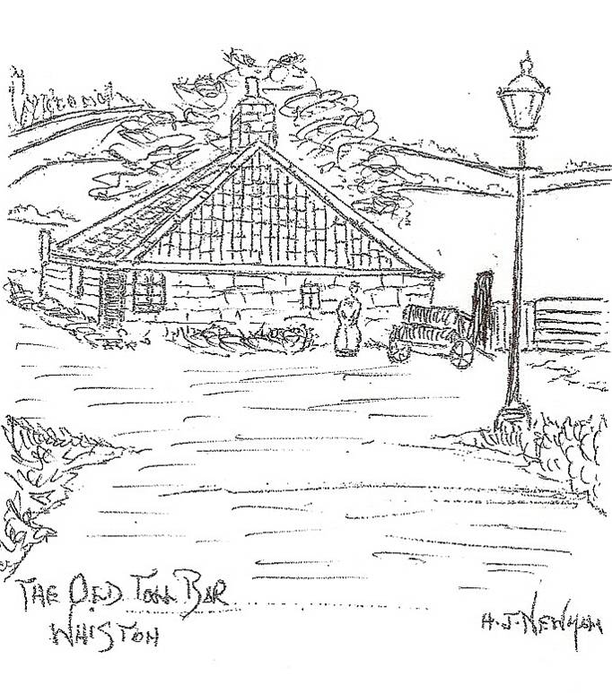
A Drawing of the Old Toll House |
|
|
This concludes our walk round Whiston village. The route is shown on the map above but a simplified version is also displayed below (together with parking places). Thank you for taking the time today to admire and appreciate the beauty, history and tranquillity of our village. | |
|
Another walk in the Whiston area is to be found here: www.rotherham.gov.uk/download/1079/doorstep_walk_no_15. |